Trail Plane Gemeinde Schwechat - wien paris - Photo
 jcm17
jcm17

User

© OpenStreetMap contributors
Length
Length
1154 km
Max alt
Max alt
788 m
Uphill gradient
Uphill gradient
26373 m
Km-Effort
Km-Effort  
1505 km
Min alt
Min alt
41 m
Downhill gradient
Downhill gradient
26438 m
Boucle
Boucle
No
Creation date :
2019-05-19 15:31:45.008
Updated on :
2019-05-19 22:21:00.827

(0 Reviews)

Plane
Plane
2h18
Difficulty : Very easy

Scan this QR Code to open this trail in the SityTrail application

FREE GPS app for hiking

Logo SityTrail SityTrail

IGN / Geographical institutes

Download SityTrail from the App Store Download SityTrail from Google Play

Logo SityTrail SityTrail World

The world is yours!

Download SityTrail from the App Store Download SityTrail from Google Play Download SityTrail on Huawei AppGallery

About

Trail Plane of 1154 km to be discovered at Lower Austria, Bezirk Bruck an der Leitha, Gemeinde Schwechat. This trail is proposed by jcm17.

Elevation profile

Positioning

Country:
Austria
Region :
Lower Austria
Department/Province :
Bezirk Bruck an der Leitha
Municipality :
Gemeinde Schwechat
Location:
Unknown
Start:(UTM)
616022 ; 5330857 (33U) N.

Trails nearby

Trail On foot Gemeinde Fischamend - Dominik Immobilien Runde (Fischamend) - Photo
On foot
GUIDE+

On foot

Easy
Gemeinde Fischamend, Lower Austria, Bezirk Bruck an der Leitha, Austria
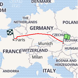
12.3 km | 13.8 km-effort
3h 8min
Yes


Close
My subscriptions